GPS
WAYPOINTS
Download GPX waypoint files for Skyline Drive & Wasatch Backcountry. Load them into Gaia GPS, OnX Offroad, Garmin, or any GPS device. Files include obstacles, campsites, trailheads, and key landmarks with coordinates and descriptions.
Waypoint Browser
Skyline Drive Trailhead
D1Starting point off Guardsman Pass road. Air down here and check your gear.
40.6234
-111.6012
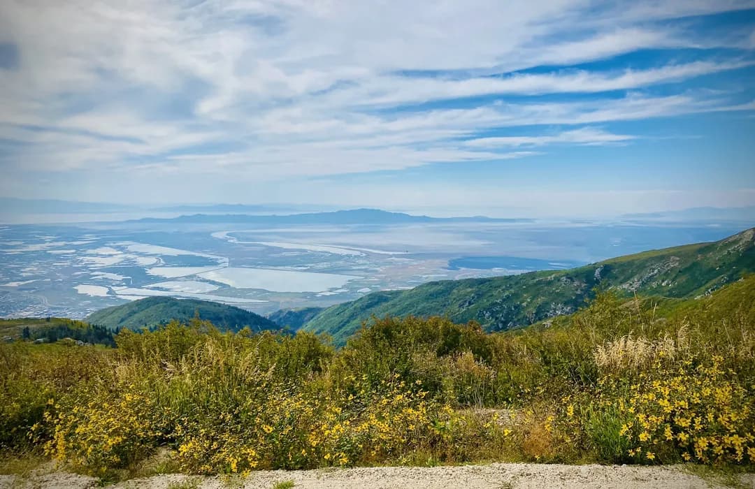
Bald Mountain Overlook
D1First major viewpoint with stunning views of Park City and the Jordanelle Reservoir below.
40.6189
-111.5934
Clayton Peak Saddle
D1Technical rocky section along the ridgeline with steep drop-offs on both sides.
40.6098
-111.5867
Desolation Lake Overlook
D2Overlook of the pristine alpine Desolation Lake nestled in a glacial cirque.
40.5987
-111.5789
American Fork Canyon Descent
D2Steep descent into American Fork Canyon with tight switchbacks and rock ledges.
40.5756
-111.5623
Tibble Fork Reservoir
D2Beautiful mountain reservoir perfect for a lunch stop. Swimming, fishing, and picnicking.
40.5412
-111.5934
Mineral Basin
D3High alpine basin at the top of Snowbird ski resort with wildflower meadows in summer.
40.5634
-111.6123
Guardsman Pass Summit
D1The high point connecting Big Cottonwood Canyon to Park City. Spectacular fall colors.
40.6312
-111.5845
Tibble Fork Campground
D1Nestled along the North Fork of American Fork Creek near Tibble Fork Reservoir. Shaded sites under tall pines with creek access.
40.5398
-111.5912
Granite Flat Campground
D1Large campground in American Fork Canyon with 68 sites spread across loops. Close to Silver Lake Flat trail.
40.5567
-111.6034
Spruces Campground
D1Popular campground in Big Cottonwood Canyon at 7,400 ft elevation. Great base for Skyline Drive.
40.6234
-111.6456
Jordanelle State Park
D1Full-service campground on the shores of Jordanelle Reservoir with lake access and mountain views.
40.6012
-111.4234
Timpanogos Cave National Monument
D1Three stunning limestone caverns connected by man-made tunnels, featuring stalactites, stalagmites, and rare helictites. Reached via a steep 1.5-mile hike.
40.4412
-111.7089
Cascade Springs
D1Natural spring-fed terraces with boardwalk trails through lush vegetation. The springs produce 7 million gallons of water daily.
40.5234
-111.6123
Park City Historic Main Street
D1Former silver mining town turned world-class resort. Walk the historic Main Street with galleries, shops, and the Egyptian Theatre from 1926.
40.6456
-111.4978
Homestead Crater
D1A 55-foot tall beehive-shaped limestone rock with a hidden hot spring inside. You can swim, snorkel, or scuba dive in 90-96°F mineral water.
40.5134
-111.4612
Stewart Falls Trail
D13.7-mile round trip hike to a spectacular 200-foot double waterfall on the slopes of Mount Timpanogos.
40.4234
-111.6345
Sundance Mountain Resort
D1Robert Redford's iconic mountain resort in Provo Canyon. Art studios, nature trails, and the famous Tree Room restaurant.
40.3912
-111.5867
Compatible Apps & Devices
Gaia GPS
Import GPX via app or gaiagps.com. Best for offline trail maps.
OnX Offroad
Import waypoints in the app. Includes trail difficulty overlays.
Garmin Devices
Copy GPX to /Garmin/GPX folder via USB. Works on all Garmin handhelds.
Google Earth
Open GPX directly in Google Earth for 3D terrain visualization.
GPS Tips for Skyline Drive & Wasatch Backcountry
- 1.Download offline maps before you leave — cell service is unreliable on most off-road trails.
- 2.Bring a battery pack or hardwired GPS. Phone batteries drain fast with GPS active.
- 3.Waypoints are approximate — canyons and rock formations can cause GPS drift of 50-100 feet.
- 4.Share your GPX with your trail group so everyone has the same waypoints.